
CHAPTER THREE: MAP READING AND INTERPRETATION
Definitions of Map
- Map is a representation usually on a flat surface of the whole or a part of an area on a flat surface like cloth, wall, piece of paper etc. For example a city or country, which shows its main features, such as its roads, rivers, mountains etc
OR. Map is a symbolic depiction emphasizing relationships between elements of some space, such as objects, regions, or themes.
Map reading is the process of identifying features on a map by using symbols and signs or names. This technical work requires certain skills that any map reader must possess.
Map interpretation is the interpretation of the symbols and signs used on map into ordinary language by indicating the features they represent and draw logical conclusions from the information as represented by the symbols.
Cartography is the study of making or drawing maps
Cartographer is a person who draws or produces maps
TYPES OF MAPS
Maps can be categorized based on various criteria. One common way to classfy them is by their purpose. Based on this criterion maps are generally divided into two main types: GENERAL PURPOSE MAPS and THEMATIC MAPS.
GENERAL PURPOSE MAPS
General purpose maps are maps designed to show a wide range of information about an area.
They are used for many different purposes, not just one specific use. They show both physical and human features such as relief, rivers, roads, towns, boundaries, and settlements.
Examples of General-Purpose Maps
1. Topographical Maps
• Show detailed physical and human features of an area.
• Include relief (using contours), rivers, forests, roads, settlements, and land use.
• Used for surveying, planning, geography studies, and navigation.
2. Political Maps
• Show administrative boundaries such as countries, regions, districts, and cities.
• Indicate capital cities, major towns, and borders.
• Used for government administration, education, and political studies.
3. Road and Railway Maps
• Show transport networks like roads, highways, railways, and stations.
• Help people to plan travel and transportation routes.
• Used by drivers, travelers, transport planners, and logistics services.
THEMATIC MAPS
Meaning of Thematic Maps
Thematic maps are maps that display specific and focused information about one particular subject (theme) in a given area. Unlike general purpose maps, thematic maps are designed to highlight one type of information only, depending on the purpose of the map. The information shown may include soil types, vegetation zones, crop distribution, population density, weather patterns, or urban planning features.
Examples of Thematic Maps
1. Population Maps
• Show the distribution, density, or growth of population in an area.
• Use shading, colors, dots, or symbols to represent population data.
• Help in planning social services, such as schools, hospitals, and housing.
2. Weather Maps
• Show weather conditions such as rainfall, temperature, wind direction, air pressure, and storms.
• Use symbols, lines (isobars), and colors to represent weather elements.
• Used for weather forecasting, disaster management, and climate studies.
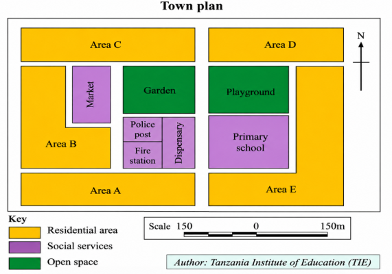
3. Urban Planning Maps
• Show land use in towns and cities, such as residential areas, industrial zones, commercial areas, roads, and public facilities.
• Help planners to design, manage, and develop urban areas efficiently.
• Used by municipal authorities and urban planners.
ESSENTIAL ELEMENTS OF A MAP
The basic skills required in understanding how to read a map include Title, Scale, Key, Indication of the north direction, Margin/Boundary and Date of compilation.
1. Tittle gives the name of the country and the area where mapped. It helps the map reader to know what the map is all about. The heading is usually printed in bold capital used on the map
2. Scale is a ratio between the distance on the map and actual distance on the ground. It is used to find actual distance and areas on the ground. On topographical maps
scales are given in form of ratio or lines.
Types of scale
i. Large scale. Are those maps drawn to large scale size e.g. 1:10000 These maps gives a larger representation of small area, they are also more detailed (shows a lot of information). They represent areas like cities, towns and villages.
ii. Medium Scale. Are those maps drawn to medium scale size e.g. 1:100000 They show a moderate amount of details. They represent areas like districts, regions and countries.
iii. Small scale Are those maps drawn to small scale size e.g. 1:1000000 They give a small presentation of a large area; they show little content (little information) They represent areas like continents and the world.
Definitions of Map
- Map is a representation usually on a flat surface of the whole or a part of an area on a flat surface like cloth, wall, piece of paper etc. For example a city or country, which shows its main features, such as its roads, rivers, mountains etc
OR. Map is a symbolic depiction emphasizing relationships between elements of some space, such as objects, regions, or themes.
Map reading is the process of identifying features on a map by using symbols and signs or names. This technical work requires certain skills that any map reader must possess.
Map interpretation is the interpretation of the symbols and signs used on map into ordinary language by indicating the features they represent and draw logical conclusions from the information as represented by the symbols.
Cartography is the study of making or drawing maps
Cartographer is a person who draws or produces maps
TYPES OF MAPS
Maps can be categorized based on various criteria. One common way to classfy them is by their purpose. Based on this criterion maps are generally divided into two main types: GENERAL PURPOSE MAPS and THEMATIC MAPS.
GENERAL PURPOSE MAPS
General purpose maps are maps designed to show a wide range of information about an area.
They are used for many different purposes, not just one specific use. They show both physical and human features such as relief, rivers, roads, towns, boundaries, and settlements.
Examples of General-Purpose Maps
1. Topographical Maps
• Show detailed physical and human features of an area.
• Include relief (using contours), rivers, forests, roads, settlements, and land use.
• Used for surveying, planning, geography studies, and navigation.
2. Political Maps
• Show administrative boundaries such as countries, regions, districts, and cities.
• Indicate capital cities, major towns, and borders.
• Used for government administration, education, and political studies.
3. Road and Railway Maps
• Show transport networks like roads, highways, railways, and stations.
• Help people to plan travel and transportation routes.
• Used by drivers, travelers, transport planners, and logistics services.
THEMATIC MAPS
Meaning of Thematic Maps
Thematic maps are maps that display specific and focused information about one particular subject (theme) in a given area. Unlike general purpose maps, thematic maps are designed to highlight one type of information only, depending on the purpose of the map. The information shown may include soil types, vegetation zones, crop distribution, population density, weather patterns, or urban planning features.
Examples of Thematic Maps
1. Population Maps
• Show the distribution, density, or growth of population in an area.
• Use shading, colors, dots, or symbols to represent population data.
• Help in planning social services, such as schools, hospitals, and housing.
2. Weather Maps
• Show weather conditions such as rainfall, temperature, wind direction, air pressure, and storms.
• Use symbols, lines (isobars), and colors to represent weather elements.
• Used for weather forecasting, disaster management, and climate studies.
3. Urban Planning Maps
• Show land use in towns and cities, such as residential areas, industrial zones, commercial areas, roads, and public facilities.
• Help planners to design, manage, and develop urban areas efficiently.
• Used by municipal authorities and urban planners.
ESSENTIAL ELEMENTS OF A MAP
The basic skills required in understanding how to read a map include Title, Scale, Key, Indication of the north direction, Margin/Boundary and Date of compilation.
1. Tittle gives the name of the country and the area where mapped. It helps the map reader to know what the map is all about. The heading is usually printed in bold capital used on the map
2. Scale is a ratio between the distance on the map and actual distance on the ground. It is used to find actual distance and areas on the ground. On topographical maps
scales are given in form of ratio or lines.
Types of scale
i. Large scale. Are those maps drawn to large scale size e.g. 1:10000 These maps gives a larger representation of small area, they are also more detailed (shows a lot of information). They represent areas like cities, towns and villages.
ii. Medium Scale. Are those maps drawn to medium scale size e.g. 1:100000 They show a moderate amount of details. They represent areas like districts, regions and countries.
iii. Small scale Are those maps drawn to small scale size e.g. 1:1000000 They give a small presentation of a large area; they show little content (little information) They represent areas like continents and the world.
Last edited: